


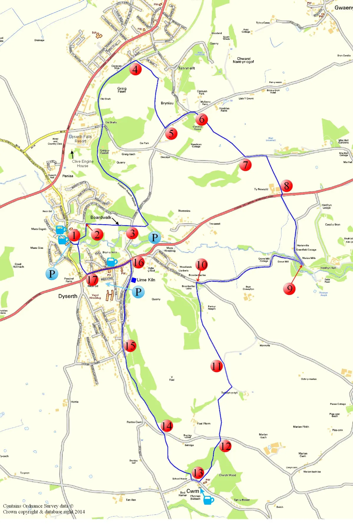
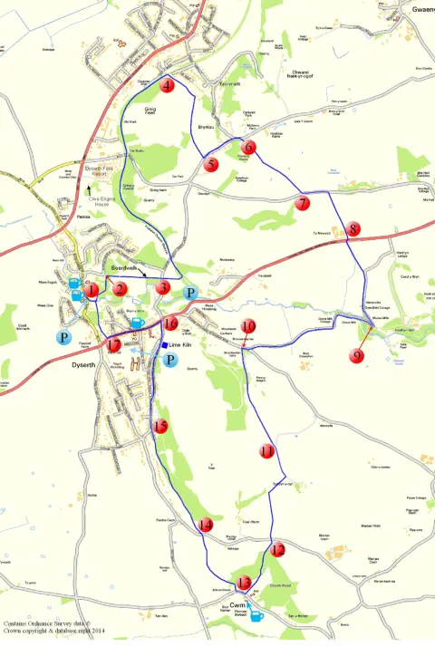
Dyserth Circular Walk
Start Point: public car park adjacent to Dyserth Waterfall. Toilets available in car park (seasonal opening).
Grid Ref: SJ 056 793, OS Explorer Map 264, Vale of Clwyd.
Distance: about 7 miles.
Time required: about 4.5 hours
Terrain: some steep hills on certain sections so a medium level of fitness is required.
1.
Leave
car
park
and
turn
left,
pass
waterfall
entrance
and
turn
left
immediately
after
Waterfall
Shop.
Climb
the
old
mill
steps,
turning
left
at
top
at
a
path
junction.
Continue
then
climb
more steps, emerging onto end of road on Bryn-y-Felin. Turn left after house and descend steps to cross causeway over River Ffyddion, continue up to pass
wooden steps
on left…
Alternatively,
turn
left
before
the
shop
and
after
paying
a
small
toll
head
towards
waterfall
through
metal
gates,
cross
river
in
front
of
the
falls
and
climb
the
stone
steps
between
the
huge
stone
walls.
Follow
path
up
the
hill,
passing
view
point
with
bench
seats
overlooking
village.
Continue
on
path
over
hill,
descending
some
wooden
steps…
onto
a
path
and
turn
left
walking through trees towards a stile.
2.
Cross stile & turn right, climbing a steep bank into an open field where there is a way-marker post.
Head across the field towards the corner of a wood where there is a stile to a fenced board-walk along the edge of woodland, towards Pandy Lane.
3.
Cross
Pandy
Lane
and
climb
steps
immediately
opposite,
through
a
kissing
gate
to
enter
an
open
meadow,
Maes
Hiraddug
-
a
Site
of
Special
Scientific
Interest
(SSSI)
owned
by
The
North Wales Wildlife Trust. Cross the field diagonally to the left towards a gate.
Cross the old railway bridge and turn sharp right, ignoring kissing gate, and take steps down to join the Dyserth to Prestatyn Walkway turning right towards Prestatyn.
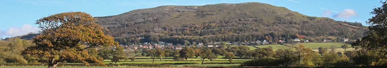
On
a
sweeping
bend
with
magnificent
views
towards
the
Ormes
and
the
Carneddau
Mountains
look
out
for
the
low-level
caves
in
the
limestone
rock
on
the
right
(fitted
with
grilles
to
prevent unauthorised entry). Follow walkway up to a wooden gate and the old stone-built railway goods shed on the left.
4.
Turn
right
on
path
opposite
the
stone
building
and
after
a
few
yards
go
through
a
kissing
gate,
following
steep
path
and
steps
up
Graig
Fawr
which
is
open
access
land
owned
by
the
National Trust.
Ignore
kissing
gate
on
left
halfway
up
this
path.
At
the
top
of
steps,
the
first
of
several
way
marker
posts
will
become
visible
showing
the
direction
of
the
route
leading
to
the
road
at
Bryniau. At a split in the path bear right following the sign for Graig Fawr to reach Bryniau.
Alternatively, you could deviate from the normal route and climb to the white trig point on top of Craig Fawr (153m/502ft) for
spectacular views of Snowdonia, Anglesey and the coast.
5.
Leave
National
Trust
land
through
kissing
gate
and
turn
left
on
road
at
Mount
House.
Follow
the
road
and
look
for
some
stone
steps
and
a
stile
on
the
right
-
6
-
which
is
on
the
Offa’s
Dyke Path. Continue on Offa’s Dyke Path crossing stiles in four fields before dropping down a steep bank onto road.
7.
Turn
left
and
follow
road,
looking
out
for
caves
on
right.
After
a
short
distance
take
first
stile
on
right
and
cross
through
two
fields
towards
A5151
Trelawnyd
road
with
Ty
Newydd
farm
on right (this section can be very muddy).
8.
Turn right on road and after about 50 yards take stile on other side of road. Continue to next stile and turn right onto a narrow road heading down towards the river.
9.
Don’t follow Offa’s Dyke path when reaching the hairpin bend but continue on the road, passing ruined Grove Mill on the left.
Continue along the road for about half a mile ignoring all stiles until you reach the T-junction with Hiraddug Road; turn right.
10.
After
a
short
distance
take
path
on
left
at
side
of
white
bungalow
and
follow
fenced
path
to
the
second
driveway
and
turn
right.
Just
before
gate
to
private
house
cross
stile
on
right
and follow path through gorse bushes to ladder stile and an open field. Cross three fields with ladder stiles until you reach metal gate on farm track.
11.
Turn right and follow track until you reach stile on right side before reaching a farm. Cross three fields with stiles and descend steps onto the lane.
12.
Opposite is a stile leading into Church Wood, take care downhill on rough ground from this stile (especially when wet) then cross two more stiles before entering a field.
You are now approaching the village of Cwm and the stile is located in the left hand corner of the field near church.
13.
Turn
right
on
road
passing
the
Blue
Lion
pub
on
left.
After
a
short
distance
take
stile
on
the
right
towards
two
more
stiles
leading
to
an
open
field.
Walk
up
middle
of
steep
banked
field looking for gate and stile at top of hill. Take time out to admire the wonderful views across the Vale of Clwyd towards Snowdonia.
Cross another field and climb over stile onto lane.
14.
Opposite
is
a
metal
kissing
gate
with
a
path
leading
along
the
lower
western
slopes
of
Moel
Hiraddug.
Follow
path
through
woodland
until
you
reach
end
of
wood
with
panoramic
display panel and bench on right.
15.
Leave
the
wood
on
a
track
which
joins
Lower
Foel
Road
and
continue
straight
on.
Branch
right
uphill
on
to
Upper
Foel
Road
and
pass
the
lime
kiln
just
before
the
road
rejoins
Lower
Foel Road. Continue straight on to the A5151 Trelawnyd Road.
16. Turn left at main road and walk through village. Pass Dyserth Garage and road to Bryn-y-Felin on right. After the old school with metal railings look out for footpath sign, on right,
before traffic lights - 17.
Follow this path until you see some stone steps on the left which will lead you down to the main road near Waterfall Shop. Turn right on the road, and back to car park.
If
you
came
up
these
steps
at
the
start
you
could
carry
on
past
them,
then
climb
some
steps,
emerging
onto
end
of
road
on
Bryn-y-Felin.
Turn
left
after
house
and
descend
steps
to
cross
bridge
over
River
Ffyddion,
continue
up
to
wooden
steps
on
left.
Climb
these
steps
and
arrive
at
viewpoint
with
bench
seats
overlooking
the
village.
Follow
fenced
path
down through huge stone walls and cross river in front of the waterfall, exit falls through metal gate and turn right for car park.
Note
this gate may be locked in the evenings.
Leaflet designed & produced by Peter J Robinson,
Dyserth Environmental Group
For more information about Dyserth and for hundreds of old photographs visit www.dyserth.com
Dyserth Circular Walk was developed as part of a series of walks linking the village with the Clwydian Range AONB. Using a grant provided by the Environment Sustainable Fund and
Objective 1 DUNE, Dyserth Environmental Group worked closely with Denbighshire Countryside Services to provide the necessary furniture and way-marking for these attractive and
contrasting walks. Printing funded by Dyserth Community Council. v2 August 2014
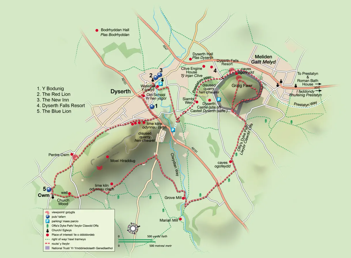
A different map of the same walk - from the Dyserth Brochure
For PDF download
see foot of page
For the walk in PDF format click below.
It is designed to be printed double sided on A4 and folded into three.
(Opens in a new window)

Dyserth
Circular Walk


Dyserth Circular Walk
Start Point: public car park adjacent to Dyserth Waterfall. Toilets
available in car park (seasonal opening).
Grid Ref: SJ 056 793, OS Explorer Map 264, Vale of Clwyd.
Distance: about 7 miles.
Time required: about 4.5 hours
Terrain: some steep hills on certain sections so a medium level of
fitness is required.
1.
Leave
car
park
and
turn
left,
pass
waterfall
entrance
and
turn
left
immediately
after
Waterfall
Shop.
Climb
the
old
mill
steps,
turning
left
at
top
at
a
path
junction.
Continue
then
climb
more
steps,
emerging
onto
end
of
road
on
Bryn-y-Felin.
Turn
left
after
house
and
descend
steps
to
cross
causeway
over
River
Ffyddion,
continue
up
to
pass
wooden steps
on left…
Alternatively,
turn
left
before
the
shop
and
after
paying
a
small
toll
head
towards
waterfall
through
metal
gates,
cross
river
in
front
of
the
falls
and
climb
the
stone
steps
between
the
huge
stone
walls.
Follow
path
up
the
hill,
passing
view
point
with
bench
seats
overlooking
village.
Continue
on
path
over
hill,
descending
some
wooden
steps…
onto
a
path
and
turn
left
walking
through
trees
towards
a
stile.
2.
Cross
stile
&
turn
right,
climbing
a
steep
bank
into
an
open
field
where there is a way-marker post.
Head
across
the
field
towards
the
corner
of
a
wood
where
there
is
a
stile
to
a
fenced
board-walk
along
the
edge
of
woodland,
towards
Pandy Lane.
3.
Cross
Pandy
Lane
and
climb
steps
immediately
opposite,
through
a
kissing
gate
to
enter
an
open
meadow,
Maes
Hiraddug
-
a
Site
of
Special
Scientific
Interest
(SSSI)
owned
by
The
North
Wales
Wildlife
Trust. Cross the field diagonally to the left towards a gate.
Cross
the
old
railway
bridge
and
turn
sharp
right,
ignoring
kissing
gate,
and
take
steps
down
to
join
the
Dyserth
to
Prestatyn
Walkway
turning right towards Prestatyn.
On
a
sweeping
bend
with
magnificent
views
towards
the
Ormes
and
the
Carneddau
Mountains
look
out
for
the
low-level
caves
in
the
limestone
rock
on
the
right
(fitted
with
grilles
to
prevent
unauthorised
entry).
Follow
walkway
up
to
a
wooden
gate
and
the
old
stone-built
railway goods shed on the left.
4.
Turn
right
on
path
opposite
the
stone
building
and
after
a
few
yards
go
through
a
kissing
gate,
following
steep
path
and
steps
up
Graig
Fawr which is open access land owned by the National Trust.
Ignore
kissing
gate
on
left
halfway
up
this
path.
At
the
top
of
steps,
the
first
of
several
way
marker
posts
will
become
visible
showing
the
direction
of
the
route
leading
to
the
road
at
Bryniau.
At
a
split
in
the
path bear right following the sign for Graig Fawr to reach Bryniau.
Alternatively,
you
could
deviate
from
the
normal
route
and
climb
to
the white trig point on top of Craig Fawr (153m/502ft) for
spectacular views of Snowdonia, Anglesey and the coast.
5.
Leave
National
Trust
land
through
kissing
gate
and
turn
left
on
road
at
Mount
House.
Follow
the
road
and
look
for
some
stone
steps
and
a
stile
on
the
right
-
6
-
which
is
on
the
Offa’s
Dyke
Path.
Continue
on
Offa’s
Dyke
Path
crossing
stiles
in
four
fields
before
dropping down a steep bank onto road.
7.
Turn
left
and
follow
road,
looking
out
for
caves
on
right.
After
a
short
distance
take
first
stile
on
right
and
cross
through
two
fields
towards
A5151
Trelawnyd
road
with
Ty
Newydd
farm
on
right
(this
section can be very muddy).
8.
Turn
right
on
road
and
after
about
50
yards
take
stile
on
other
side
of
road.
Continue
to
next
stile
and
turn
right
onto
a
narrow
road
heading down towards the river.
9.
Don’t
follow
Offa’s
Dyke
path
when
reaching
the
hairpin
bend
but
continue on the road, passing ruined Grove Mill on the left.
Continue
along
the
road
for
about
half
a
mile
ignoring
all
stiles
until
you reach the T-junction with Hiraddug Road; turn right.
10.
After
a
short
distance
take
path
on
left
at
side
of
white
bungalow
and
follow
fenced
path
to
the
second
driveway
and
turn
right.
Just
before
gate
to
private
house
cross
stile
on
right
and
follow
path
through
gorse
bushes
to
ladder
stile
and
an
open
field.
Cross
three
fields with ladder stiles until you reach metal gate on farm track.
11.
Turn
right
and
follow
track
until
you
reach
stile
on
right
side
before
reaching
a
farm.
Cross
three
fields
with
stiles
and
descend
steps onto the lane.
12.
Opposite
is
a
stile
leading
into
Church
Wood,
take
care
downhill
on
rough
ground
from
this
stile
(especially
when
wet)
then
cross
two
more stiles before entering a field.
You
are
now
approaching
the
village
of
Cwm
and
the
stile
is
located
in the left hand corner of the field near church.
13.
Turn
right
on
road
passing
the
Blue
Lion
pub
on
left.
After
a
short
distance
take
stile
on
the
right
towards
two
more
stiles
leading
to
an
open
field.
Walk
up
middle
of
steep
banked
field
looking
for
gate
and
stile
at
top
of
hill.
Take
time
out
to
admire
the
wonderful
views
across
the Vale of Clwyd towards Snowdonia.
Cross another field and climb over stile onto lane.
14.
Opposite
is
a
metal
kissing
gate
with
a
path
leading
along
the
lower
western
slopes
of
Moel
Hiraddug.
Follow
path
through
woodland
until
you
reach
end
of
wood
with
panoramic
display
panel
and bench on right.
15.
Leave
the
wood
on
a
track
which
joins
Lower
Foel
Road
and
continue
straight
on.
Branch
right
uphill
on
to
Upper
Foel
Road
and
pass
the
lime
kiln
just
before
the
road
rejoins
Lower
Foel
Road.
Continue straight on to the A5151 Trelawnyd Road.
16. Turn left at main road and walk through village. Pass Dyserth
Garage and road to Bryn-y-Felin on right. After the old school with
metal railings look out for footpath sign, on right, before traffic lights -
17.
Follow
this
path
until
you
see
some
stone
steps
on
the
left
which
will
lead
you
down
to
the
main
road
near
Waterfall
Shop.
Turn
right
on
the road, and back to car park.
If
you
came
up
these
steps
at
the
start
you
could
carry
on
past
them,
then
climb
some
steps,
emerging
onto
end
of
road
on
Bryn-y-Felin.
Turn
left
after
house
and
descend
steps
to
cross
bridge
over
River
Ffyddion,
continue
up
to
wooden
steps
on
left.
Climb
these
steps
and
arrive
at
viewpoint
with
bench
seats
overlooking
the
village.
Follow
fenced
path
down
through
huge
stone
walls
and
cross
river
in
front
of
the
waterfall,
exit
falls
through
metal
gate
and
turn
right for car park.
Note
this gate may be locked in the evenings.
Leaflet designed & produced by Peter J Robinson,
Dyserth Environmental Group
For more information about Dyserth and for hundreds of old
photographs visit www.dyserth.com
Dyserth Circular Walk was developed as part of a series of walks
linking the village with the Clwydian Range AONB. Using a grant
provided by the Environment Sustainable Fund and Objective 1
DUNE, Dyserth Environmental Group worked closely with
Denbighshire Countryside Services to provide the necessary
furniture and way-marking for these attractive and contrasting walks.
Printing funded by Dyserth Community Council. v2 August
2014
A different map of the same walk
- from the Dyserth Brochure

For PDF download
see foot of page
For the walk in PDF format click below.
It is designed to be printed double sided on A4
and folded into three.
(Opens in a new window)
Dyserth
Circular Walk